
Heavy storms, damaging winds predicted for Nelson County overnight
STAFF REPORT
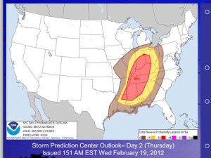
This map indicates the areas likely to experience severe weather events. Click to enlarge.
Wednesday, Feb. 18, 2014, 11:55 a.m. — Two rounds of potentially severe thunderstorms will pass through our area in the next 24-36 hours according to the latest report from the Louisville office of the National Weather Service.
The first storms will arrive in Central Kentucky in the overnight hours early Thursday morning. Damaging winds in excess of 60 mph are likely with this storm, along with heavy cloud-to-ground lightning.
A second storm front will arrive late Thursday afternoon and evening, bringing the potential for more damaging winds in excess of 60 mph with the added threat of tornadoes.
The recent icing events, melting snow and rainfall have created soggy ground conditions, and high winds may lead to a higher-than-normal number of downed trees and tree limbs.
Heavy rains may also create localized flooding to the saturated ground conditions.
-30-


